Serra do Rio do Rastro: the history, engineering and itinerary of the most winding road in Brazil
Fog that closes the runway in minutes, ice in winter and a view of the sea 100 km away: what the Serra do Rio do Rastro requires — and offers — to those who travel it
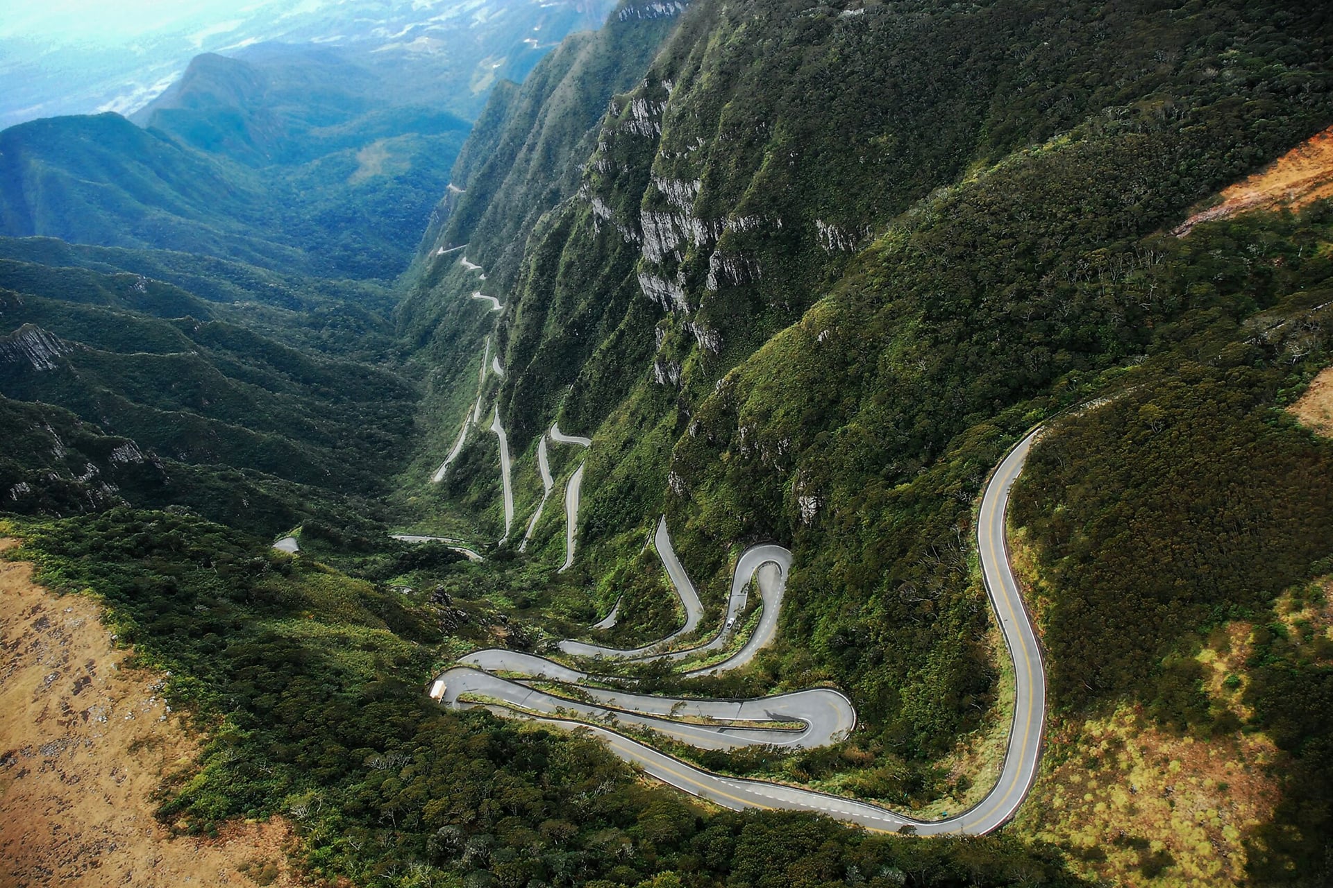
Serra do Rio do Rastro has already been elected the most beautiful road in Brazil in different polls (Photos: Disclosure)
There is a stretch of about 24 kilometers in the south of Santa Catarina in which the road seems to give up the straight line. The SC-390, at the height of the Serra do Rio do Rastro, stacks 284 curves on the wall of the Serra Geral, rises from about 200 to 1,460 meters in altitude and, on clear days, offers a view of the ocean from the top of the mountain range. It is not by chance that the road has become a postcard of Santa Catarina and an almost obligatory pilgrimage for motorcyclists and car lovers.
From muleteers to concrete
Before the asphalt — even before the beaten ground — the path was a trail of muleteers. Until the first decades of the twentieth century, cattle and goods overcame the wall through steep trails traveled by mules, and it was from them, from the tracks left near the river, that the name of the mountain came from. The idea of transforming the road into a road came in the late 1920s from intendant Joaquim Goulart, in the region of Bom Jardim da Serra.
The works dragged on for decades. The mountain was opened to traffic still as a dirt road in the mid-1950s and had its inauguration celebrated around 1960. The definitive finish only came between 1984 and 1986, when the SC-390 became the first highway in Santa Catarina paved in concrete — a technical choice, not an aesthetic one, to which we will return later.
Why is the track so winding
The answer lies in geology. The Serra do Rio do Rastro cuts through the escarpment of Serra Geral, the eastern edge of the great basaltic plateau of the Paraná Basin. This wall was born from lava flows that occurred about 130 million years ago, in the Cretaceous, which covered an ancient sandstone desert; Subsequent uplift and millions of years of erosion carved the basalt wall and neighboring canyons. The result is an almost vertical step, with a difference of up to 1,200 meters between the coastal plain and the mountain plateau.
It is this unevenness that dictates the design. To overcome more than a thousand meters in height in a short horizontal space, without creating an impassable ramp for cars, buses and trucks, engineering had only one way out: to stretch the route. Every sharp turn, every elbow in the road, exists to dilute the slope into distance — to exchange a steep climb for a long, manageable track. The 284 curves, therefore, are not a scenographic whim: they are the translation, in asphalt and concrete, of a stone wall. And concrete has its own function: adhesion. At the top of the mountain range, where ice forms in winter, it grips the tire better than conventional asphalt.
Safely ascend and descend
The same altitude that delivers the landscape demands the driver’s attention. The biggest risk of the Serra do Rio do Rastro is not the abyss, but the fog, which rises from the coast and closes the lane in minutes. On days of fog, the guidance of the Military Highway Police is to reduce speed, keep distance and use low or fog lights – never high beams, which worsen visibility. The speed limit in the mountain range is 40 km/h.
In winter, ice and the possibility of snow are added, capable of interdicting the stretch. PMRv teams even spread salt on the road to prevent freezing, as happened now, at the end of June. On the way down, the engine brake is a golden rule: using the foot brake all the time overheats the system. It is also worth checking the conditions of the road before going up (the PMRv phone number is 198, and there are live cameras from the mountains), refueling at the base, bringing warm clothing even in the summer and, if possible, avoiding weekends and holidays, when the viewpoint is crowded and the traffic behind buses and trucks drags on. The best window of visibility is usually between 11 am and 3 pm, when the fog gives way.
Where to stay and what to see
The tip from those who know it is simple: do both directions. Going up through Lauro Müller, at the base, and going down through Bom Jardim da Serra, at the top – or the other way around – reveals completely different perspectives of the same road. The main viewpoint, at 1,460 meters, is the mandatory stop; In addition, a family of coatis usually welcomes visitors.
For accommodation, the icon of the region is the Rio do Rastro Eco Resort (SC-390, km 402), which brings together trails, mountain gastronomy and the traditional Creole shed. The Hotel Du Rastro has the particularity of being the only one located on the mountain road itself, with panoramic balconies. Those who prefer the boutique format will find Jardim das Pedras and Vistas de Mantiqueira, both with very few chalets and open views of the valley. São Joaquim and Urubici, about an hour away, function as more structured bases — the first famous for its apples and high-altitude wineries ( the Pousada Maçã Araucária is one of the best rated); the second, the gateway to Morro da Igreja and its waterfalls.
In the immediate surroundings, make time for the Ronda Canyon, with its wind farm, and the Laranjeiras Canyon, in Bom Jardim da Serra — even more photogenic on winter mornings, when the fog sinks into the valley and the visitor starts to observe the clouds from above.
Comments are the sole responsibility of their authors and do not represent the opinion of this site. Comments containing profanity or offensive language will not be published. If you identify anything that violates the terms of use, please report it.


")


")
